February 17, 2026
The Sidewalk Priority Score can help users identify where a new or reconstructed sidewalk would have the greatest impact. This information can help support a grant application, aid in project selection, or provide a starting point for considering where sidewalks are most needed.
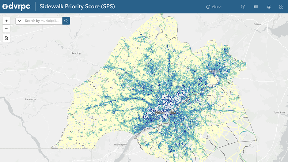
DVRPC has released a new tool, the Sidewalk Priority Score, which identifies and prioritizes needed sidewalk connections in the Greater Philadelphia region. The web map features road segments that are missing complete sidewalks on both sides of the road. Based on transportation conditions, needs, and nearby destinations, these segments are assigned a score from 1 to 10, with 10 being the highest priority. The score can help users identify where a new or reconstructed sidewalk would have the greatest impact. This information could be used to support a grant application, aid in project selection, or provide a starting point for considering where sidewalks are most needed.
Please note: Sidewalk data changes regularly. If you notice an error, such as a road segment identified as missing a sidewalk that now has a sidewalk, please contact Cassidy Boulan at cboulan@dvrpc.org.
The Sidewalk Priority Score is one of a number of tools available from DVRPC for pedestrian planning. Other tools that may be useful to municipalities, planners, community organizations, and activists are:
Greater Philadelphia Pedestrian Portal - This is a centralized hub for information on DVRPC’s multilayered approach to improving pedestrian infrastructure in the region. Use the “Explore” and “Edit” functions to access maps and edit DVRPC's regional pedestrian network GIS dataset. Here you can also find information on resources and opportunities to help communities build more sidewalks.
LINK - This web-based tool allows users to draw or upload proposed bicycle or pedestrian facility locations to analyze their connectivity impacts. The tool estimates the number of people, jobs, services, and amenities that would be newly connected by these improvements, offering data-driven insights for prioritizing projects.
AccessScore - This analysis assesses the infrastructure and demographic characteristics around transit stations that relate to how supportive of bicycling and walking the area is and how much bicycle and pedestrian activity could be occurring there. The analysis includes Regional Rail, light rail, trolley, and subway stations throughout the Philadelphia region with service provided by SEPTA, NJ TRANSIT, and PATCO.
Sidewalk and Street Tree Screening Tool - This map identifies locations in the DVRPC region where sidewalk repair and street tree planting would have the greatest impact based on extreme heat vulnerability, tree canopy coverage, sidewalk density, and other data.
Learn more about Pedestrian Planning at DVRPC.